Readers of this blog will recall several posts involving instances of Barn Owls being struck by vehicles on major roads (see HERE and HERE, for example).
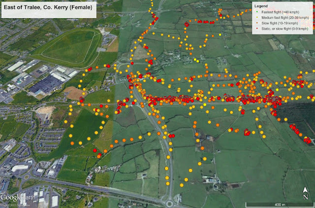
Continuing with our project to discover the effects of major roads on Barn Owl populations (in conjunction with T.I.I.), in July 2017 we tracked a female Barn Owl whose home range included the Tralee Bypass (see a history of this nest site HERE). While we long suspected that the adult Barn Owls from this site might well be hunting along the Bypass, the findings from the GPS data loggers were astonishing... Over 11 nights, she hunted along the verges of the Bypass nine times, and crossed the road 14 times.
The Tralee Bypass, near Manor West, looking north, showing multiple tracks of the female Barn Owl along and over the Bypass over 11 nights in July ((J.Lusby/M.O'Clery, under licence from NPWS and BTO).
She also frequently perched along the verges, spending around two hours close to the road. The dangers to the bird are obvious and yet, she and her partner not only survived, but managed to raise two chicks this summer.
Have a look at a detailed video of the GPS tracking of this owl below. You can click on the 'four arrows' symbol on the bottom right to see a full-screen HD view.
Barn Owl tracking of a female Barn Owl near the Tralee Bypass, July 2017 (J.Lusby/M.O'Clery, under licence from NPWS and BTO).
Please share this video on social media - see links at bottom of this post.
Track of Barn Owl over 12 nights, near Dingle, July 2017 (J.Lusby/M.O'Clery, under licence from NPWS and BTO).
Above, a screengrab of the GPS tracking of one of the Barn Owls near Dingle showing just part of the movements of the bird over 12 nights in July 2017. The water body here on the left is Smerwick Harbour, the beach in the lower left corner is Baile an Reannaigh, a spot familiar to many birders. Red dots are where the bird is stationary, Orange is slow hunting flight, yellow is faster flight.
More on this project on the Irish Raptor Blog HERE.

